CASE STUDY SNAPSHOT
Customer : A leading construction equipment OEM serving construction, warehousing, and real estate sectorsSize : > 200–1000
Project vertical : Construction Technology, Consumer Electronics
Challenge : Develop a cross-platform mobile application that connects to multiple proprietary LiDAR-based distance measurement devices over a custom BLE mesh protocol, enables structured floor area measurement across standard and complex polygon shapes, and exports professional floor plans as PDF documents
Solution : Android and iOS floor measurement application with custom BLE mesh protocol integration, multi-device simultaneous connectivity, standard and polygon area measurement modes, gyroscope-based surface flatness measurement, hand-drawn floor plan mode, and PDF export
Services & Products Availed : Mobile Application Development, UI/UX Design Services, Embedded Firmware Integration
Tools and Technologies:
- Platforms: Android, iOS
- Languages: Kotlin, Swift
- Connectivity: BLE GATT with custom mesh protocol
- Sensors: LiDAR (proprietary), device gyroscope
- Measurement: Custom geometry engine
- Export: PDF generation
- Frameworks: BLE GATT, Custom BLE Mesh Stack
Introduction
Accurate floor measurement is a foundational requirement across construction, warehousing, interior design, and real estate — yet traditional measurement methods remain largely manual, time-consuming, and prone to human error. Laser distance meters help, but they typically operate as isolated single-device tools, requiring measurements to be manually recorded and calculated, with no direct path from raw measurements to a usable floor plan document.
A leading construction equipment OEM approached Embien to develop a mobile application that would transform their proprietary LiDAR-based distance measurement hardware into a connected, intelligent measurement system. The application had to enable multiple LiDAR devices to work together simultaneously over a custom BLE mesh network, support structured floor area measurement across rectangular, triangular, and complex polygon layouts, capture surface flatness data using the device's built-in gyroscope, and produce professional PDF floor plan exports — all from a single smartphone or tablet.
Challenge
The core technical challenge was the custom BLE mesh protocol. The customer's proprietary LiDAR devices communicate over a mesh network built on standard BLE, but with a custom application-layer protocol governing device discovery, ranging command dispatch, measurement data collection, and multi-device synchronisation. Embien had to implement this protocol stack in both Kotlin and Swift, ensuring behaviorally identical operation on Android and iOS despite their substantially different native BLE APIs and stack behaviors.
Supporting simultaneous connectivity to multiple LiDAR devices introduced further complexity. In a real measurement scenario, a field engineer may deploy several devices around a room to capture all wall distances in a single pass. The application had to manage independent BLE connections to each device concurrently, synchronise measurement triggering across the mesh, and aggregate the returned distance values into a coherent spatial model of the space being measured.
The geometry engine presented its own challenges. Rectangular and square areas are straightforward, but construction and real estate spaces are frequently irregular — L-shaped rooms, triangular alcoves, angled walls, and complex multi-sided polygons. The measurement engine had to correctly compute area, perimeter, and sub-region dimensions for arbitrary polygon shapes drawn by the user, with measurement data from the LiDAR devices accurately anchored to the corresponding walls or surfaces.
Finally, the PDF export had to produce output of sufficient professional quality for use in project documentation, client presentations, and regulatory submissions — not merely a screenshot of the application screen.
Solution
Custom BLE Mesh Protocol Integration
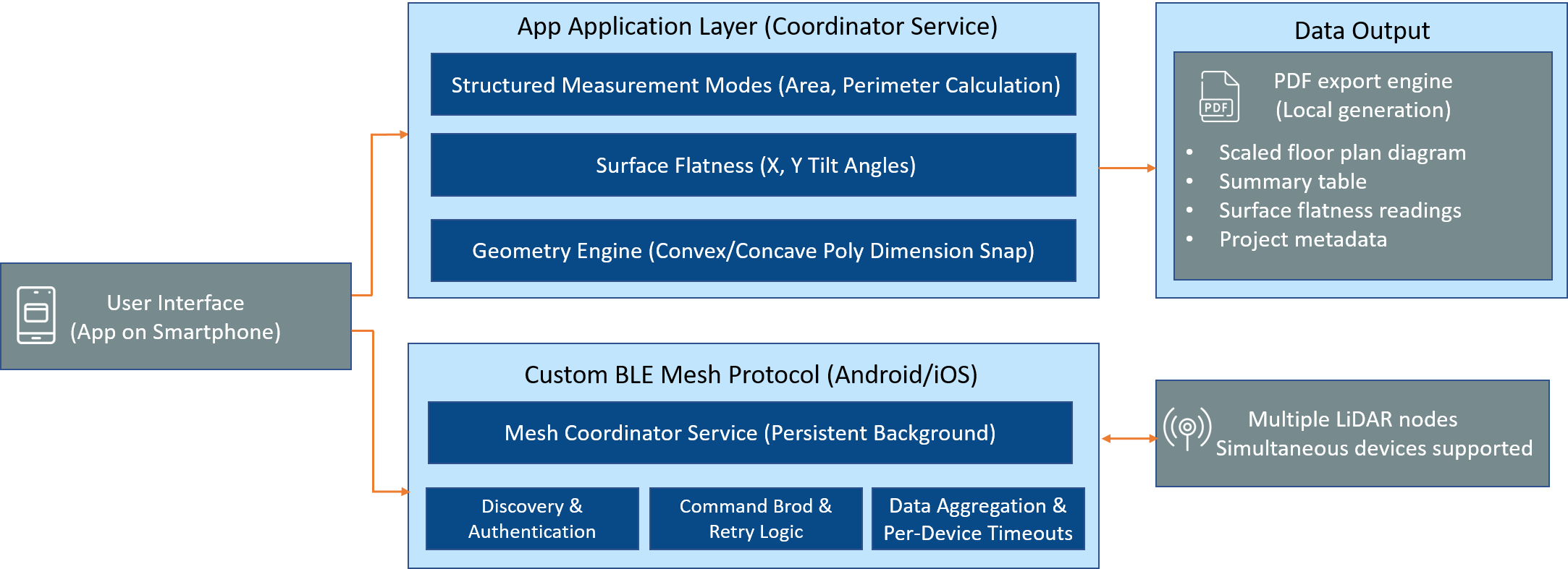
The BLE layer was implemented as a full custom mesh stack on both Android and iOS, faithfully implementing the customer's proprietary application-layer protocol over standard BLE GATT. The stack handles device discovery through directed advertisement scanning with custom service UUID filtering, device authentication and session establishment, ranging command broadcast across the mesh, and measurement response collection with per-device timeout handling and retry logic.
The mesh coordinator role — managing command sequencing and data aggregation across all connected LiDAR nodes — runs within a persistent background service on the smartphone. This enables the application to maintain active mesh sessions while the user is actively drawing or annotating the floor plan, without measurement connectivity being interrupted by foreground UI activity. Multiple LiDAR devices are supported simultaneously, with the practical limit determined by the BLE concurrency capabilities of the host device.
Structured Area Measurement Modes
The application provides three structured measurement modes, each designed for a specific category of space.
Rectangle and Square Mode handles the most common case — a simple, four-walled room. The user places LiDAR devices at the relevant walls, triggers a measurement pass, and the application computes length, width, area, and perimeter automatically, displaying results on a scaled on-screen plan view.
Triangle Mode supports triangular sub-spaces — bay areas, angled alcoves, or irregular corner regions. LiDAR measurements to three walls or reference points define the triangle, with the geometry engine computing area using the captured side lengths.
Polygon Mode is the most powerful measurement mode, supporting arbitrary multi-sided spaces. The user defines the polygon by placing LiDAR devices or reference points at each vertex of the space. As measurements are captured, the geometry engine constructs the polygon incrementally, computing area using a generalised polygon area algorithm that correctly handles both convex and concave shapes. This mode supports pentagon, hexagon, and higher-order polygons — covering the full range of irregular spaces encountered in real construction and real estate measurement scenarios.
In all modes, individual wall and segment measurements are displayed alongside the computed area and perimeter, giving the field engineer full dimensional visibility of the captured space.
Surface Flatness Measurement
The application integrates the smartphone's built-in gyroscope to provide surface flatness measurement — a capability particularly valuable in construction quality inspection contexts. The user places the phone on a surface and the application displays live X and Y tilt angle values on an interactive graph, providing a real-time visual indication of surface deviation from horizontal. Flatness readings can be captured and included in the PDF export alongside the floor plan data, consolidating spatial measurement and quality inspection into a single workflow.
Hand-Drawn Floor Plan Mode
For situations where a field engineer needs to sketch a floor plan that goes beyond the structured measurement modes — recording spatial context, annotating existing features, or capturing a layout before LiDAR measurements are taken — the application provides a hand-drawn floor plan mode. Using touch input, the engineer draws structured shapes — walls, openings, partitions, and room boundaries — on a blank canvas. Shapes snap to standard angles and lengths for cleaner output. Annotations, labels, and dimension callouts can be added to the sketch. The hand-drawn plan can be used standalone or combined with LiDAR measurement data to produce an annotated floor plan export.
PDF Export
The PDF export engine produces professional-quality floor plan documents from the captured measurement data. Each exported document includes a scaled floor plan diagram with all measured dimensions annotated, computed area and perimeter values, surface flatness readings where captured, a measurement summary table, and basic project metadata — site name, date, engineer name, and notes. The export is formatted for standard A4 output, suitable for inclusion in project documentation, client deliverables, and regulatory submissions. Exports are generated locally on the device without requiring cloud connectivity, ensuring availability in the field regardless of network conditions.
Benefits
- Custom BLE mesh integration Full proprietary mesh protocol implemented natively on both Android and iOS, enabling simultaneous multi-device LiDAR connectivity with reliable measurement synchronisation
- Complete polygon measurement Rectangle, triangle, and arbitrary polygon area measurement with a generalised geometry engine covering all real-world construction and real estate space shapes
- Surface flatness inspection Gyroscope-based flatness measurement integrated into the same workflow as floor area capture, consolidating spatial measurement and quality inspection
- Professional PDF export Device-local document generation produces project-ready floor plan PDFs without cloud dependency, ensuring field availability in all connectivity conditions
- Broad application coverageA single application serves construction site measurement, warehouse layout planning, real estate floor plan capture, and interior design space assessment
Conclusion
This floor measurement application demonstrates Embien's ability to develop sophisticated mobile tools that tightly integrate with proprietary hardware through custom communication protocols. By implementing the customer's BLE mesh protocol natively on both Android and iOS, supporting the full range of polygon measurement scenarios, and producing professional PDF exports, Embien delivered an application that transforms standalone LiDAR hardware into a connected, intelligent measurement platform. The addition of gyroscope-based surface flatness measurement and hand-drawn floor plan capability further extends the tool beyond basic distance measurement into a comprehensive field survey instrument — one that meaningfully reduces measurement time, eliminates manual calculation errors, and produces directly usable documentation for construction, warehousing, and real estate applications.